Exploring Scrub Island
Anguilla, Caribbean
Signs of an Old Plantation


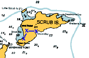
Just beyond the natural stone bridge, we we find ourselves back at Souse Bay beach.
We cross our own path for the first time, and see our footprints leading off toward the airplane crash. We can either go back along the south edge of the flat area, the same way we came, or take an intriguing track along the north edge.
We select the northern route and soon come upon more intriging stone walls.
Only these walls enclose a large round hole in the ground that is plastered. It appears to be a cistern.
We pass two more cisterns, the last with a large amount of water in it. And find ourselves at a small pond. We feel like we should be back at our starting beach.
We walk along the thick brush and trees that line the beach. We can see that there are sailboats anchored just over the small rise, but we can't find a way through. We probably could have gone around the north end of the bush, but our cool water and our ride home is at the south end of the beach. So we walk all the way south along the seagrape and prickly bush barrier. We can hear the waves beating just yards away. Finally we reach the clearing we started from...