Our Anguilla
 Anguilla is a British dependent territory which exists in
the West Indies(the Caribbean). It is the most north-easterly of the Leeward Islands/Leeward Antilles. It is located 18 degrees North of the Equator
and 63 degrees West of the Greenwich meridian. The Atlantic bathes the northern and
western coastlines, while the Caribbean Sea bathes the south and west; both help to make Anguilla a stunning isle of tranquility wrapped in blue. Anguilla is 35 square miles; 16 miles vertically from the north-eastern to south-western tips of the island. The island is widest at three and a half miles,and its narrowest at half a mile wide.
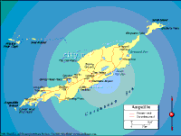
Anguilla is a British dependent territory which exists in
the West Indies(the Caribbean). It is the most north-easterly of the Leeward Islands/Leeward Antilles. It is located 18 degrees North of the Equator
and 63 degrees West of the Greenwich meridian. The Atlantic bathes the northern and
western coastlines, while the Caribbean Sea bathes the south and west; both help to make Anguilla a stunning isle of tranquility wrapped in blue. Anguilla is 35 square miles; 16 miles vertically from the north-eastern to south-western tips of the island. The island is widest at three and a half miles,and its narrowest at half a mile wide.

